Question for Scottb613

Collapse
X
 
  • Time
  • Show
Clear All
new posts
  • tarrant75
    Senior Member


    • Jul 2004
    • 590
    • The East, but wanting to go back West
    • English, 'Merican, Australian and Sarcasm
    • MSOR

    #1

    Question for Scottb613

    I've been trying to get the PolyVeg Planter to work. I've run SCO Lidex program and I keep gettiing below message. I have the polyveg.json file but the other one is totally off the wall. Not sure where its supposed to be, what it's supposed to be or how it's supposed to generated.

    Any help would be greatly appreciated
    image.png
    - Chris N.

    There's no fear for tomorrow
    When there's no trust for today
  • scottb613
    2500 Post Veteran


    • Apr 2003
    • 2848
    • Downeast Maine (soon)
    • ORTS

    #2
    Hi Chris,

    For this to work - you need to use LIDEX and TSRE GenX - as a matched pair. If your terrain mesh is all set - and you just want to plant - you need to run LIDEX to pull all the OSM Map Data for your route. Make sure LIDEX shows v1.401. This can take a significant amount of time to process as the amount of data processed can be massive.

    The options you want are illustrated below.


    In TSRE GenX v0.16 - when LIDEX has completed its run - hit the [m] key to make sure your full OSM Map Data is loaded.

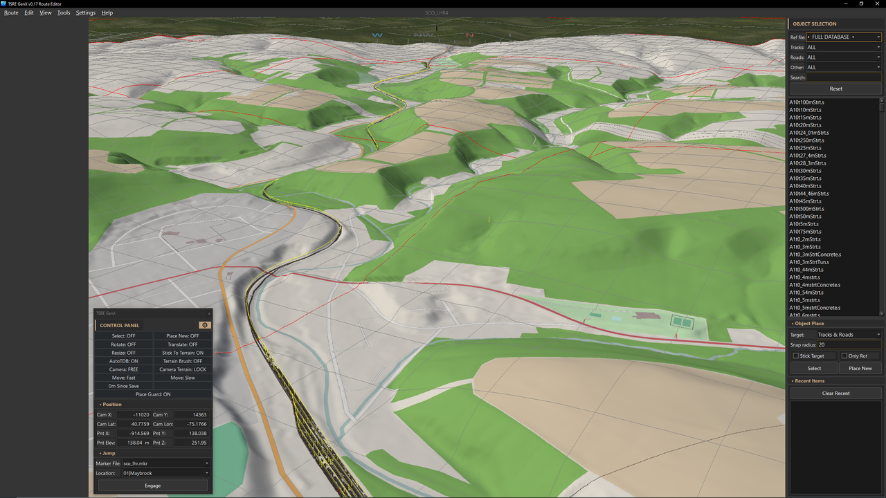
    Hit F6 to open PolyVeg - if you have a vegetation schema already defined - simply aim at a rural OSM poly and right click - like the green one - and select [Plant PolyVeg]. Should populate the region with your defined schema and settings.

    Now this is only half of it - when you're done planting a tile or four - the tens of thousands of trees will slow down TSRE. Simply hit [Bake PolyVeg Area] and it will combine those tens of thousands of models into a few shapes.

    If you're unhappy - simply select one of the new shapes - it selects all on a tile - and hit delete. This process works by tile - so you are baking and deleting - by tile. Save when done.

    Capture.jpg

    If you don't have a schema to select - hit [EDIT SCHEMA] and build and save a new one.

    Capture2.jpg


    Hope this helps.

    Regards,
    Scott
    Last edited by scottb613; 09-14-2026, 19:34.
    <a href=https://www.trainsim.com/forums/filedata/fetch?filedataid=80663&type=full title=thumb_80663.png >thumb_80663.png</a>​ My Blender Models

    Comment

    • eric
      9500 Post Veteran and Administrator


      • Dec 2002
      • 9583
      • NS MP245.4 CNO&TP South District
      • English, SQL
      • General

      #3
      Originally posted by scottb613
      you need to run LIDEX to pull all the OSM Map Data for your route
      What will that do to any existing Google Maps or MapBox terrtex?
      If you like what you see here at Trainsim.com, be it the discussions and knowledge in the forums, or items available in our library, I hope you'll consider a paid membership to help support keeping the site operating.... Thanks!

      Comment

      • tarrant75
        Senior Member


        • Jul 2004
        • 590
        • The East, but wanting to go back West
        • English, 'Merican, Australian and Sarcasm
        • MSOR

        #4
        I've done the new Schematic, I've built the OSM, but I'm missing something for some reason

        image.png image.png

        ​
        - Chris N.

        There's no fear for tomorrow
        When there's no trust for today

        Comment

        • scottb613
          2500 Post Veteran


          • Apr 2003
          • 2848
          • Downeast Maine (soon)
          • ORTS

          #5
          Originally posted by eric
          What will that do to any existing Google Maps or MapBox terrtex?
          Hi Eric,

          I need to figure out a new means to handle satellite imagery. I did look at adding it to LIDEX but I don't want to be responsible for something - if it runs unintended - or runs amok - might cost the user money. I know OSM and Satellite Imagery is an either/or situation - I don't have an answer for you - at this moment. I'll see what I can do.

          Regards,
          Scott
          <a href=https://www.trainsim.com/forums/filedata/fetch?filedataid=80663&type=full title=thumb_80663.png >thumb_80663.png</a>​ My Blender Models

          Comment

          • scottb613
            2500 Post Veteran


            • Apr 2003
            • 2848
            • Downeast Maine (soon)
            • ORTS

            #6
            Originally posted by tarrant75
            I've done the new Schematic, I've built the OSM, but I'm missing something for some reason
            Hi Chris,

            Just a quick clarification on how PolyVeg determines where it can and can’t plant, as this comes up frequently — especially for users relying primarily on satellite imagery.
            • PolyVeg only plants on recognized OSM rural land‑use polygons:
              • forest
              • woodland
              • field
              • scrub
              • wetlands
            • In your screenshot, I’m only seeing satellite imagery — I can’t see any OSM land‑use data underneath it. If the OSM layer doesn't have a land use polygon underneath, PolyVeg has no way to classify the terrain.
            • If an area has no OSM land‑use polygon, planting is blocked by default. Satellite imagery alone doesn’t provide the classification PolyVeg needs.
            • The Ruler and Area Tool have their own PLANT button on the right hand panel.

            If you want to plant in areas with missing OSM coverage, enable [UNRESTRICTED] in the side panel. With this option turned on, you can plant almost anywhere.
            • Even with [UNRESTRICTED] enabled, PolyVeg will still skip the following hard exclusions:
              • OSM roads
              • OSM waterways
              • OSM tracks
              • OSM building footprints
              • TDB
              • RDB
            • The ruler/area tool can include these exclusions inside your footprint — PolyVeg will simply skip over them according to the rules you’ve set.
            • This is why OSM data is always helpful. It ensures consistent planting behavior and prevents gaps where the tool doesn’t know what the land is supposed to be.

            I have more PolyVeg improvements planned for the next release, and I’ll see what I can do to better support users who rely primarily on satellite imagery.

            I did spend a considerable amount of time building USER GUIDES - to help with all the changes I have made.

            USER GUIDES for TSRE GenX:
            scottb613/TSRE5-SCOmod · Discussions · GitHub


            Regards,
            Scott
            Last edited by scottb613; 09-15-2026, 07:21.
            <a href=https://www.trainsim.com/forums/filedata/fetch?filedataid=80663&type=full title=thumb_80663.png >thumb_80663.png</a>​ My Blender Models

            Comment

            • scottb613
              2500 Post Veteran


              • Apr 2003
              • 2848
              • Downeast Maine (soon)
              • ORTS

              #7
              Hi Folks,

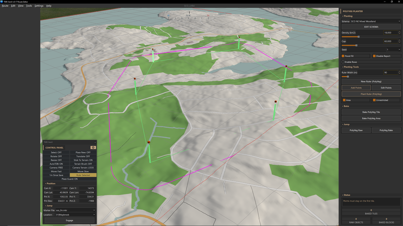
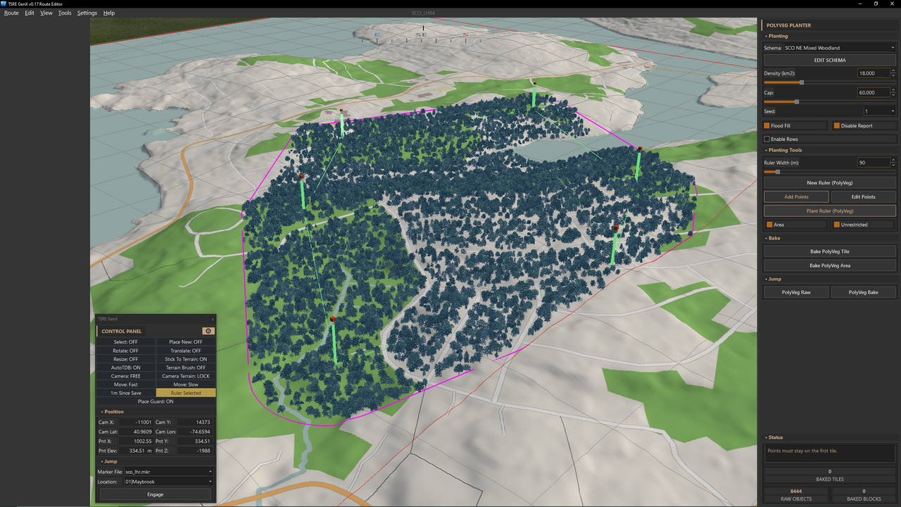
              Just tested [UNRESTRICTED] again with the AREA Tool - the RULER Tool works same way - just in a line. The blue color vegetation is only in my development version - to indicate RAW PolyVeg units - the tint is removed when BAKED.

              As you can see - PolyVeg can plant anywhere - while still respecting the aforementioned exclusions. The light beige areas are those areas without any OSM land-use polygon. Notice it hits a hard line at the tile border that it will not crossover - makes it super simple to have PolyVeg forests seamlessly continue across tile borders without having to be precise with footprints.

              Took all of 10 seconds.


              AREA Tool [UNRESTRICTED]:


              AREA Tool [UNRESTRICTED]:


              Regards,
              Scott
              Last edited by scottb613; 09-15-2026, 09:08.
              <a href=https://www.trainsim.com/forums/filedata/fetch?filedataid=80663&type=full title=thumb_80663.png >thumb_80663.png</a>​ My Blender Models

              Comment

              • eric
                9500 Post Veteran and Administrator


                • Dec 2002
                • 9583
                • NS MP245.4 CNO&TP South District
                • English, SQL
                • General

                #8
                Originally posted by scottb613
                I need to figure out a new means to handle satellite imagery. I did look at adding it to LIDEX but I don't want to be responsible for something - if it runs unintended - or runs amok - might cost the user money. I know OSM and Satellite Imagery is an either/or situation - I don't have an answer for you - at this moment. I'll see what I can do.
                Yeah,that would be great but wasn't the question.

                If I run the LIDEX app to pull in the OSM maps, will that overwrite existing Terrtex? If so, it's a simple matter of backing up the existing before proceeding.
                If you like what you see here at Trainsim.com, be it the discussions and knowledge in the forums, or items available in our library, I hope you'll consider a paid membership to help support keeping the site operating.... Thanks!

                Comment

                • scottb613
                  2500 Post Veteran


                  • Apr 2003
                  • 2848
                  • Downeast Maine (soon)
                  • ORTS

                  #9
                  Originally posted by eric

                  Yeah,that would be great but wasn't the question.

                  If I run the LIDEX app to pull in the OSM maps, will that overwrite existing Terrtex? If so, it's a simple matter of backing up the existing before proceeding.
                  Hi Eric,

                  No—LIDEX’s OSM map generation does not touch your existing Terrtex. It uses the same map-overlay system as TSRE, saving PNG files in the route’s terrain_maps folder.

                  Converting a map into Terrtex is a separate TSRE operation—Make Tile Texture From Map—which LIDEX does not perform.

                  LIDEX will overwrite matching PNGs in terrain_maps, so back up that folder if you want to preserve your satellite map overlays. Your existing Terrtex files remain untouched.

                  Sorry—I misunderstood your question.

                  Regards,
                  Scott
                  <a href=https://www.trainsim.com/forums/filedata/fetch?filedataid=80663&type=full title=thumb_80663.png >thumb_80663.png</a>​ My Blender Models

                  Comment

                  • scottb613
                    2500 Post Veteran


                    • Apr 2003
                    • 2848
                    • Downeast Maine (soon)
                    • ORTS

                    #10
                    Hi Folks,

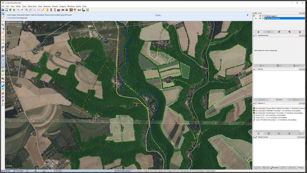
                    Just another OSM tip — different parts of the world vary widely in the amount and quality of OSM coverage, simply because it’s a community‑driven project. That doesn’t need to slow you down. Creating OSM data is actually very easy: it’s basically tracing polygons over satellite imagery and uploading them. You can’t invent features that don’t exist, of course — everything must reflect the real terrain — but this method captures the natural randomness of the landscape far better than anything you could hand‑draw in the route editor.

                    For example, the hills climbing up from Martins Creek on the old LHR had almost no usable OSM coverage. I opened JOSM, traced my first polygon, and uploaded it — the whole process took about ten minutes, and it goes even faster once you get the hang of it. The next day, that new polygon appeared in the OSM download. Honestly, this approach is faster and produces better results than trying to recreate all that terrain manually. Plus, you’re contributing back to the OSM community.


                    JOSM


                    My Land-Use Polygons created at Martins Creek - with JOSM


                    NOTE: Why yes - that is the new 4m HD Terrain Mesh created from 1m LIDAR data...


                    Regards,
                    Scott
                    Last edited by scottb613; 09-15-2026, 13:21.
                    <a href=https://www.trainsim.com/forums/filedata/fetch?filedataid=80663&type=full title=thumb_80663.png >thumb_80663.png</a>​ My Blender Models

                    Comment

                    • tarrant75
                      Senior Member


                      • Jul 2004
                      • 590
                      • The East, but wanting to go back West
                      • English, 'Merican, Australian and Sarcasm
                      • MSOR

                      #11
                      Going to try re-doing the OSM data through Lidex. Really hope I'm not doing something wrong here

                      image.png
                      Last edited by tarrant75; 09-15-2026, 18:37.
                      - Chris N.

                      There's no fear for tomorrow
                      When there's no trust for today

                      Comment

                      • scottb613
                        2500 Post Veteran


                        • Apr 2003
                        • 2848
                        • Downeast Maine (soon)
                        • ORTS

                        #12
                        Originally posted by tarrant75
                        Going to try re-doing the OSM data through Lidex. Really hope I'm not doing something wrong here
                        Hi Chris,

                        I need you to confirm a few things from the instructions above so we can narrow this down:
                        1. Before testing in TSRE, had you run LIDEX with OSM / Map Tiles enabled and let it finish successfully? Your latest screenshot shows it still processing.
                        2. Did you select UNRESTRICTED in the PolyVeg panel?
                        3. Did you draw an Area or Ruler and click its PLANT button on the right hand panel?

                        Unrestricted still requires the exclusion data generated by LIDEX, so LIDEX must finish successfully first.

                        2100 tiles is a huge route in my book - it takes over an hour to crunch 600 tiles on my machine - in LIDEX.

                        From your screenshot - it looks like LIDEX is doing its thing.

                        Regards,
                        Scott

                        <a href=https://www.trainsim.com/forums/filedata/fetch?filedataid=80663&type=full title=thumb_80663.png >thumb_80663.png</a>​ My Blender Models

                        Comment

                        • tarrant75
                          Senior Member


                          • Jul 2004
                          • 590
                          • The East, but wanting to go back West
                          • English, 'Merican, Australian and Sarcasm
                          • MSOR

                          #13
                          1. I did, this is my second attempt in case I did something wrong.
                          2. I think I did Area as opposed to as opposed to Unrestricted. Will have to check to see if that was my problem earlier today, Tried Unrestricted right at this second and it's not letting me. Will try that again after Lidex finishes again,
                          3. The Plant button - not sure if I'm missing something - unless it's plant ruler, in which case it gives me the same errors as the top of the page

                          image.png
                          - Chris N.

                          There's no fear for tomorrow
                          When there's no trust for today

                          Comment

                          • scottb613
                            2500 Post Veteran


                            • Apr 2003
                            • 2848
                            • Downeast Maine (soon)
                            • ORTS

                            #14
                            Hi Chris,

                            I added tooltips to many of the controls - yep - for your first test - I would have both AREA and UNRESTRICTED selected for what you're trying to do.

                            Regards,
                            Scott
                            <a href=https://www.trainsim.com/forums/filedata/fetch?filedataid=80663&type=full title=thumb_80663.png >thumb_80663.png</a>​ My Blender Models

                            Comment

                            • weichenpfleger
                              Member
                              • May 2010
                              • 37
                              • Germany (Deutschland)
                              • Deutsch; English with Deepl

                              #15
                              Hi Scott!
                              Unfortunately, LIDEX doesn’t work at all with my huge power grid (Western Germany).
                              I’ve attached the log file.

                              Greetings

                              Franz
                              Attached Files

                              Comment

                              Working...