Blue Comet Lines Redux Route 1965-1976 - A Work In Progress Part Deux

Collapse
X
 
  • Time
  • Show
Clear All
new posts
  • MMSS
    Senior Member

    • Aug 2009
    • 842
    • Somewhere in the swamps of Jersey (NJ)
    • MSOR

    #1

    Blue Comet Lines Redux Route 1965-1976 - A Work In Progress Part Deux

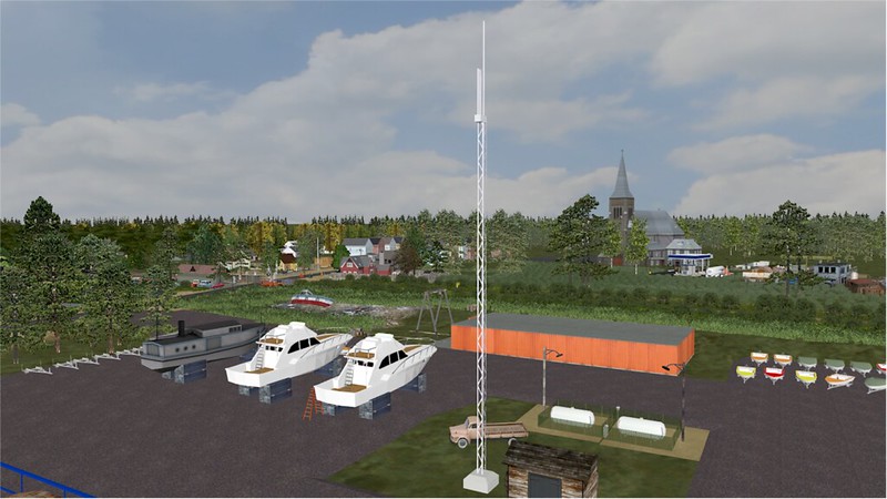
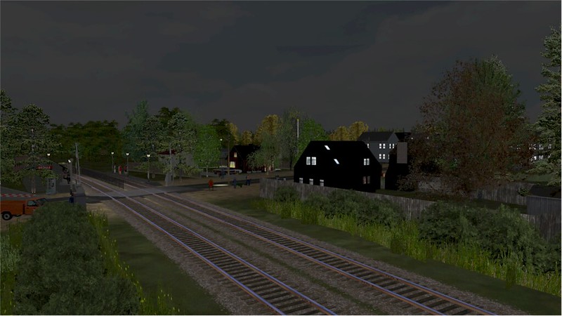
    Well it looks like the post I made two days ago was a victim of whatever happened overnight Just in brief, I ain't dead yet and NO the project isn't vaporware. I been working on the Red Bank & Seaside Park areas on the route recently and did a lot of work in other areas of the route since my last post.

    These are the screens from the post that went Poof. I will be posting some screens from the Seaside Park area later today.


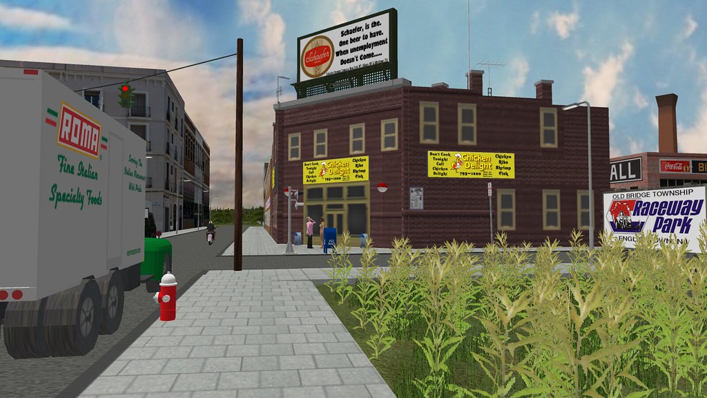


    Enjoy....... Mark
    - Mark -
  • MMSS
    Senior Member

    • Aug 2009
    • 842
    • Somewhere in the swamps of Jersey (NJ)
    • MSOR

    #2
    The other part I been working on when I need a change is Seaside Park, NJ. This is where the PRR came onto the barrier island on the 7000' Barnegat Bay trestle from Ocean Gate. This is where the PRR made the 12 mile jaunt to Bay Head Jct. until 1946. Because on the morning of Dec. 1, 1946, an arsonist burned a 300'+ section of the trestle. An the time there was a serial arsonist burning railroad trestles including the total destruction of the Matawan Creek trestle on the NYLB that disrupted service between Matawan to Bay Head Jct. for 4 days until a shoo-fly was built temporarily. Service was cut back to Bay Head Jct. on the east end. Service was cut back to Barnegat Pier Station then weeks later to Ocean Gate. By the summer of 1947 rail service was cut back to South Toms River closing The Barnegat Pier station along with stations in Ocean Gate, Pine Beach and Beachwood. The PRR filed with the ICC formal abandonment of the line from Beachwood to Bay Head Jct. in 1947 after public hearings. In 1948 the PRR closed Beachwood Tower by the PRR/CNJ diamond.

    By late 1949, the tracks were torn up between Bay Head Jct. to South Seaside Park. There were only 2 customers on the line Barnegat Ice in Seaside Heights and Seaside Lumber in South Seaside Park along with two team tracks. So it was not profitable to keep the line which later became part of the new alignment for NJ Route 35 South. At that time also the removal of the rest of the 7000' span across the bay began.

    On the west end at the time Beachwood tower was razed. Tracks were torn up from Ocean Gate to South Toms River and passenger traffic ceased by mid-1950. The line now strictly freight only lasted until 1953-54 when parts of the old ROW became part of the Garden State Parkway. By 1954 the PRR removed tracks from South Toms River to Pemberton except for a small connector track to Fort Dix near Pemberton. The station In South Toms River was moved and became a private residence in Beachwood and still stands today.

    By 1954, what was once known as the Philadelphia and Long Branch line on the PRR's Atlantic Division cease to exist.

    Now mind you, none of this infrastructure didn't exist the mid 1960's, it was 11 years removed at a minimum. So this is taking a bit of planning to be a "What if?" type of fantasy line. Lucky being I was a NJSFFS fireman for a few years and knew a lot of people working in the state. I got transparency maps of those areas of NJ for 1945, 1966 and 1975. This is helping a lot for planning this out. Goes to show you fiction can be fact. Most of the realignment mostly starts at Seaside Heights up to Manaloking near the Manaloking automobile bridge (You remember that one, it was the bridge that was washed out from Hurricane Sandy). But the way I have it mostly planned would work today if fiction was fact.

    I started at South Seaside Park, a small hamlet and the last residential town on the island. Beyond the tiny hamlet starts Island Beach State Park, a 10 mile state park that ends at Barnegat Inlet. A beautiful untouched park that was incorporated in 1953.

    So enough of my BS, I just wanted to give you a little insight to the area in case you aren't familiar with the area. So here is the first look of this area.

    The entrance to Island Beach State Park (IBSP). Great beaches for swimming, surfing and surf fishing. You can get a 4W drive permit and drive on the beach. I used to love night surf fishing for Blues, Weaks and Stripers. Thanks to Travis' Park Set and other goodies, it made doing the entrance here easy.


    IBSP entrance at sunset. Still lots of traffic enters for the surf fishing on both the Atlantic and Barnegat Bay side. Best part of coming out was stopping at Berkeley Seafood for a great seafood dish and a cold one. There is a version of Berkeley Seafood in the download library here.


    The PRR's Seaside Park station, located just north of the trestle that came into Seaside Park. Today the police station for the town sits on the former site of the station. Notice the spelling of Seaside is two words. That is how the railroad spelt it though the proper way was Seaside as one word. And the "PK" on the small board was the telegraph call letters for the PRR.


    Many summer morning people come and rent a rowboat to do a little crabbing or fishing. Many a morning at 4AM I was out there myself with my 18' open skiff with a 9HP Johnson kicker. Filling bushels of blueclaws and then fishing for snapper blues. By 9AM the shallows of the bay was like a parking lot of rowboats.


    You can always count on Betty and Nick's Tackle and Bait for all your need for fishing or crabbing. I remember when they opened at 3AM and open until 10PM. But after hours there was always someone in there to still service your needs. My favorite place to get ice on my way to IBSP.


    I think at one time Betty and Nick's also was a boat dealer, I can't say for sure so I made them a Glastron dealer just to add a little to the scene. It will be one of numerous marinas and boat dealers that will be on the route.


    St. James RC Church in "The Park". The priest during the 80's I knew and he loved to crab. I see him out on a rowboat crabbing near Rider's Cove many times and he always run out of bait. I always went out with enough bunker when crabbing so I always load him up with some. I showed him how to bait a dropline or a trap properly so he didn't give the crabs a free feast. I told him you want the give them a last supper not a free feast. He always laughed and was a great sport.


    The Beachcomber sold everything for milk to treble hooks. The real one I remember use to have these two old Italian men sitting out in front of it most of the day. One use to ask how was my catch today. Then he always tell me, "That is nothing, I can tell you about how many throw backs alone I have you be jealous.". Well I found out from my mom years later he was actually family, a second uncle of mine. But one thing, he always had a fish story to tell.


    A nice, quiet view just offshore on the Barnegat Bay. A perfect evening for a walk along the shore as long as the green-head flies aren't out. (buzzzzzzzzz).


    One thing you don't have at sea-level is water pressure. So all along the barrier island are water towers, 4 leg, 5 leg, 6 leg and cylinders. You still can go from the bottom of the island to the end at Bay Head and know the town you are in from reading the towers. Last night I finally finished all the towers for the island from South Seaside Park to Bay Head.


    Enjoy...... Mark
    - Mark -

    Comment

    • eric
      9500 Post Veteran and Administrator


      • Dec 2002
      • 9583
      • NS MP245.4 CNO&TP South District
      • English, SQL
      • General

      #3
      THANK YOU for reposting this.

      It's the small details like 1970's movie titles on the theater marquee that make a route project like yours stand out.

      on edit: I just noticed my rental signs. Glad they came of use to someone after ten years.
      If you like what you see here at Trainsim.com, be it the discussions and knowledge in the forums, or items available in our library, I hope you'll consider a paid membership to help support keeping the site operating.... Thanks!

      Comment

      • niknak
        1000 Post Veteran


        • Nov 1999
        • 1254
        • UK.
        • MSOR

        #4
        VERY nice indeed! Thank you for posting these
        Regards,

        Nick

        ( ' boffin0_reprised ' on TikTok )


        Cyberpower Desktop with AMD Ryzen 5 CPU /. 16GB RAM /. ATI AMD Radeon RX6700 12GB graphics /. Windows 11 Home 64bit /. RailDriver /. Partridge in a pear tree....​

        Comment

        • MMSS
          Senior Member

          • Aug 2009
          • 842
          • Somewhere in the swamps of Jersey (NJ)
          • MSOR

          #5
          Originally posted by eric
          THANK YOU for reposting this.

          It's the small details like 1970's movie titles on the theater marquee that make a route project like yours stand out.

          on edit: I just noticed my rental signs. Glad they came of use to someone after ten years.
          Well you know that is the point when doing this. When close to the tracks to make the objects something indigenous to the location & era.

          And as for your rental boards, well I couldn't live without them doing this project. They started popping up along the Jersey Shore about 1969-1970. Every business you can think of was using them. From Liquor Stores, No-Tell Motels, Road Side Stands, "Adult" Stores, Bars and Jukejoints, New and Used Car Dealers, Auto Repair Shops, Marinas to name a few. They still line the roads down there to this day. Some use the newer "Diamondvision" type digital boards today. But most of the places down there are Ma and Pa type businesses so this older type boards you made in all three styles still get a workout.

          - Mark -

          Comment

          • R. Steele
            3500 Post Veteran

            • Feb 2013
            • 3928
            • known universe
            • ORTS

            #6
            It's a staggeringly wonderful route. The routes I most appreciate are those that successfully convey a specific time and place...takes a lot of creative work to make that a reality. This route is really a standout. Thanks.
            Cheers, Gerry
            "A mind is like a parachute. It doesn't work if it is not open." Frank Zappa
            It's my railroad and I'll do what I want! Historically accurate attitude of US Railroad Barons.
            Forever, ridin' drag in railroad knowledge.
            Audi, Vide, Tace, Si Vis Vivere In Pace​

            https://www.trainsim.com/forums/filedata/fetch?filedataid=79656&type=medium​ https://www.trainsim.com/forums/filedata/fetch?filedataid=79654&type=small

            Comment

            • jdgremsjr
              Senior Member and Moderator

              • Dec 2007
              • 239
              • Fulton Missouri
              • Python, PHP, HTML, Javascript, CSS, My-SQL, English
              • MSOR

              #7
              Looks great, but I do see one small flaw. The police vehicles are from the late 1990s to early 2000s which is about 20 to 30 years newer than the route, but I guess if that is all you had to work with that is understandable. I hope you release it publicly I wouldn't mind getting my hands on that beautiful route.
              Pacific Northwest Railfan

              Comment

              • MMSS
                Senior Member

                • Aug 2009
                • 842
                • Somewhere in the swamps of Jersey (NJ)
                • MSOR

                #8
                Originally posted by jdgremsjr
                Looks great, but I do see one small flaw. The police vehicles are from the late 1990s to early 2000s which is about 20 to 30 years newer than the route, but I guess if that is all you had to work with that is understandable. I hope you release it publicly I wouldn't mind getting my hands on that beautiful route.
                I do know that and I did mention that in the original post before its soul was hurled into the great void. I am using them as a placeholder basically until I can come up with something better and more era related. Have to use what I can use at the time. The route will be released publicly hoping for the 1st beta of it to be released around the new year.

                Here is the original thread that started on 1-30-2019 for the project. I figured new forum layout, new thread instead of bumping the old one.

                Screen shots of Open Rails operations
                - Mark -
                Comment

                • necrails
                  Senior Member
                  • Jul 2003
                  • 152
                  • Fanwood, N, Union.

                  #9
                  Haunted Mansion at Long Branch, boy does that bring back memories. Long Branch looks nothing like this today.

                  Comment

                  • MMSS
                    Senior Member

                    • Aug 2009
                    • 842
                    • Somewhere in the swamps of Jersey (NJ)
                    • MSOR

                    #10
                    Originally posted by necrails
                    Haunted Mansion at Long Branch, boy does that bring back memories. Long Branch looks nothing like this today.
                    Well thanks to the success of Brigantine Castle (1976) near Atlantic City on Brigantine Island the same owners built the Haunted Mansion at Long Branch opening in 1978. It met its fate on June 8, 1987 when the now famous Long Branch Pier fire claimed everything on the pier along with most of the boardwalk shops. I fought that fire with mutual aid departments for 3 days.

                    A few tests I did on Long Branch does show a Haunted Mansion does show from around the old Long Branch station, more so at night. So yes this icon along with Brigantine Castle will show up as "Easter Eggs" on the finished route.
                    - Mark -

                    Comment

                    • MMSS
                      Senior Member

                      • Aug 2009
                      • 842
                      • Somewhere in the swamps of Jersey (NJ)
                      • MSOR

                      #11
                      Well, it has been a while since I posted an update for the route, so sorry to bump the thread but I rather keep the updates all together. Things went a bit slower than the last pace because of 2 more surgeries and twice a week treatment on my leg, but I still manage a steady pace on it. But any-who, let me get down to brass tacks here.

                      I am 99% completed with the downtown Red Bank area around the station and stopped just shy of "BANK" (or RG) Tower because I wanted to work a little more on the CNJ Seashore Branch. I stopped on the Seashore Branch a while back just before I entered Keansburg. So, I figure I start heading down towards Highlands again. But before that I started working on the NYLB just north of the Manasquan Draw at Brielle. I always have 2 or 3 points I am working on doing this, so I don't suffer from burn-out. The Point Pleasant Beach & Bayhead areas of the NYLB I will do once I have a few things I am re-texturing done.

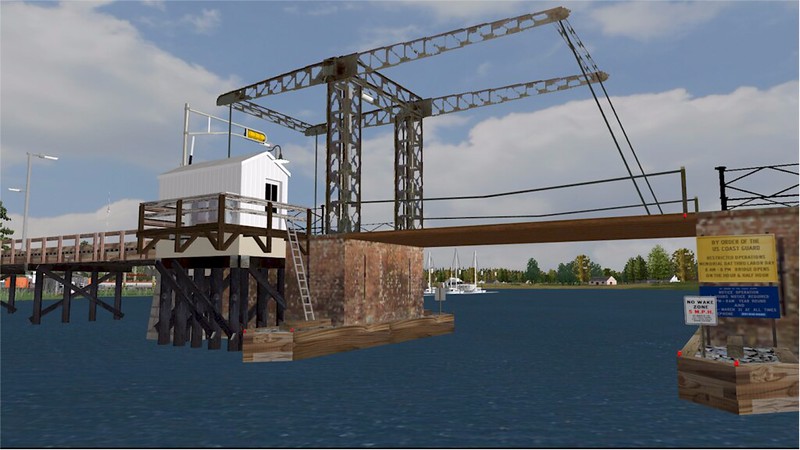
                      The 1st major area of Brielle north of the drawbridge is the "Glimmer Glass". The Glimmer Glass is a brackish water tidal lake and inlet that connects from the Manasquan River. It is one of the many small lakes and ponds that are parallel to the tracks on the NYLB. But the unique part of the Glimmer Glass is the cable lift bascule bridge that was opened in 1898 carrying Fisk Ave over the lake. It uses a rolling counterweight design for the lift. It is one if the not the only version of this kind of bridge in the eastern US and has been on the National Register of Historic Places since 2018. There are plans to replace the bridge because the bridge is restricted with no truck traffic. But there is a fight to preserve the bridge for pedestrian and bike traffic or just keep it in a raised position. The bridge is visible from the train (I seen it many times over the years when heading to and from Bay Head) so that is why I figured a way to place it in.

                      The screenshots below are of the Brielle station - Glimmer Glass area still a work in progress. Trying to get use to this new way of posting the photos. I am used to the old way by linking my BBCode from Flikr but it seems not to work. So please bear with me if they screenshots don't look shape. I will learn it in time..........

                      The "Glimmer Glass" Bridge (Day and Night Views) that carries Fisk Ave from Brielle to Manasquan. I found his example of a bridge that looks close to it from a distance on a Euro Train Sim site. I just had to add a control cab, wood walkways, bridge fenders, navigation lights, boating signs, buoys and gates and lights for the roadway.

                      ORTS_GG_01 by Mark, on Flickr

                      ORTS_GG_02 by Mark, on Flickr

                      ORTS_GG_03 by Mark, on Flickr

                      ORTS_GG_04 by Mark, on Flickr

                      ORTS_GG_05 by Mark, on Flickr​​
                      ​​
                      ​​
                      I have a few screens I took of the Keansburg area too I will post in a day or two. The route is really coming to life and starting to look a lot like that 1965 -1976 era as I remember it in my youth.

                      I also over the last few weeks released in the D/L library here some vintage billboards of the early to mid 1970's here. Week lacked billboards of that era in the library so some of the ones I made for the route here and a few that I modified for my own use I released here. Both in wooden and modern Hy-Pylon styles. So, I hope you can use them if you have a need for them.

                      ENJOY.......... Mark​
                      Last edited by MMSS; 03-23-2024, 15:36. Reason: Fix The Screenshots, FINALLY !!!!!!!!
                      - Mark -

                      Comment

                      • MMSS
                        Senior Member

                        • Aug 2009
                        • 842
                        • Somewhere in the swamps of Jersey (NJ)
                        • MSOR

                        #12


                        EDIT March 23, 2024 - FINALLY THE SCREENSHOTS ARE FIXED AND MY SENIOR MOMENT IS OVER !

                        The following are of the Brielle Station and Glimmer Glass area of Brielle.

                        ORTS_GG_06 by Mark, on Flickr

                        ORTS_GG_08 by Mark, on Flickr

                        ORTS_GG_07 by Mark, on Flickr

                        ORTS_GG_09 by Mark, on Flickr

                        ORTS_GG_10 by Mark, on Flickr


                        Last edited by MMSS; 03-23-2024, 15:43. Reason: FINALLY FIXED !!!!
                        - Mark -

                        Comment

                        • johnnyboi1066
                          New Member
                          • Mar 2024
                          • 1

                          #13
                          Wow, this looks absolutely incredible! Can't wait to see this released, must have taken you a long time to make. Is this all done on route editor?

                          Comment

                          • MMSS
                            Senior Member

                            • Aug 2009
                            • 842
                            • Somewhere in the swamps of Jersey (NJ)
                            • MSOR

                            #14
                            Originally posted by johnnyboi1066
                            Wow, this looks absolutely incredible! Can't wait to see this released, must have taken you a long time to make. Is this all done on route editor?
                            The route I didn't create. The original route is the Blue Comet Lines made by Steve Dunham in the download library on this forum. His version of the route is the 1929 to 1941 era when the CNJ's Blue Comet ran between Jersey City and Atlantic City. I wanted to do a version of the CNJ's last bankruptcy era (1965-1976) because it is the era I remember growing up in NJ. My version is about 60% done with the scenery. And yes, I am using the TSRE route editor in creating it because first it is very user friendly to use over the Microsoft Route Editor and 2nd, I am using some scenery objects that have .dds type textures for Open Rails. And the Microsoft editor only recognize .ace type textures and would crash on you.

                            BTW if you want to download the original Blue Comet Route in the library here. I suggested Steve Dunham's Blue Comet Lines 2 Route also available in the library here. It was released last year (The original version was released in 2012). The new version Has the CNJ's mainline going past Elizabethport (E'Port) to Allentown, PA and has the Reading's New Jersey Division from Bound Brook, NJ to West Trenton, NJ. I started this update before his second version was released so that is why I am using the older version.
                            - Mark -

                            Comment

                            • MMSS
                              Senior Member

                              • Aug 2009
                              • 842
                              • Somewhere in the swamps of Jersey (NJ)
                              • MSOR

                              #15
                              OK, I think I finally think I figured out the screenshot posting on here so here we go on showing you the Keansburg area of the CNJ Seashore Branch.

                              Keansburg is on the shores of the Raritan Bay. And is the only town on the Bayshore to have an amusement area. Though a lot think it is a boardwalk down by the rides, it is actually all a concrete paved area. The boardwalk that was there in the early 1900's was destroyed in a winter storm before 1930. Most of the rides are of the kiddie type but they had some in that era for adults.

                              But starting the early 1960's, Keansburg along with a lot of the seashore towns and cities in the off season (Sept. 15th to April 30th) become what is called "Welfare Towns". The motels, hotels and rooming houses instead of closing for the season stay open and became temporary subsidized housing. By the late 1960's Keansburg along with a few other towns (Long Branch, Asbury Park, Seaside Heights to name a few) became high crime and drug pushing and use areas. This continued until the med 1990's when some cities like Long Branch and Asbury Park started to finally clean their acts. Though some towns still have temp subsidized housing, they are strict if you get caught. They got smart after 25+ years.

                              The screenshots below are the beginning of doing Keansburg circa 1969-1970. Most of the look and places were there through the Conrail era even though the tracks were taken up to IFF (NATCO) in Union Beach between 1972-1974.

                              Remember, all this is a work in progress (WIP) in the very early stages.


                              A look down Main Street right near the tracks. The Grooved Disc Music Store was a great place to get hard to find, imported and even "Bootleg" records right into the 1990's. They opened about 1967 and the owner was an old Beatnik that I use to see a lot at The Inkwell, a famous old Bohemian hangout in Long Branch. It was the Jersey Shore's version of "Cafe Wha?". Below is both a day and night view.

                              ​Open Rails 2024-03-23 06-48-11 by Mark, on Flickr

                              ​Open Rails 2024-03-23 06-48-27 by Mark, on Flickr


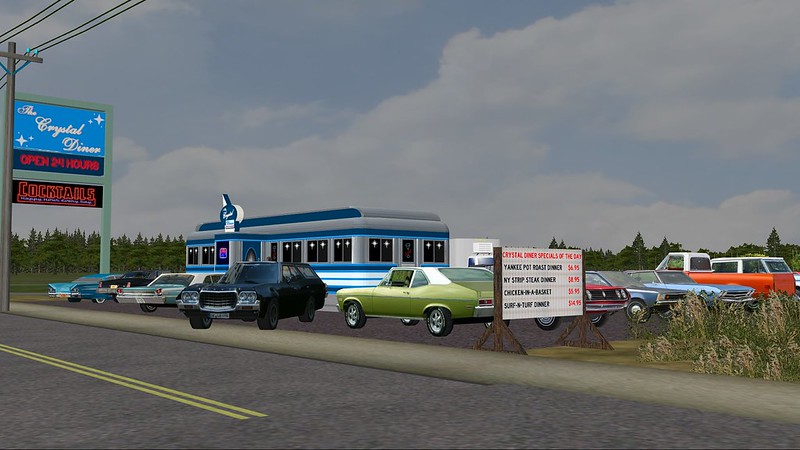
                              There used to be a diner near the tracks on Main Street that I can't remember the name of for the life of me. A few people that I know that are locals to this area said they are sure it was named The Crystal Diner and was a medium with darker blue and silver. So, I repainted and named Paul Charland's Diner from the library here to use here. I am going to ask Paul if I can release it and the others I redid in case anyone needs an extra named diner or two on the route they are making or modifying. Shown in both day and night views here.

                              ​Open Rails 2024-03-23 06-50-00 by Mark, on Flickr

                              ​Open Rails 2024-03-23 06-50-24 by Mark, on Flickr


                              I remember saying in previous posts one of my main things is to have the "eye candy" of the route close to the tracks. Little things and scenes that reflect the era. Here we have someone's summer home one the Bayshore with them having a little BBQ. The coals are just lit and the family is just hanging out getting ready to grill soon. A nice scene that just adds a little umph in either direction. Both day and night views shown here.

                              ​Open Rails 2024-03-23 06-52-45 by Mark, on Flickr

                              ​Open Rails 2024-03-23 06-53-03 by Mark, on Flickr

                              A look west down Main Street in front of the Grooved Disc. The CNJ was known for on the branch to put warning lights on their crossbucks and they will be installed in time here.

                              ​Open Rails 2024-03-23 06-47-37 by Mark, on Flickr


                              ​​​​​
                              - Mark -

                              Comment

                              Working...