SCO LIDEX goes GLOBAL

Collapse
X
 
  • Time
  • Show
Clear All
new posts
  • scottb613
    2500 Post Veteran


    • Apr 2003
    • 2848
    • Downeast Maine (soon)
    • ORTS

    #31
    Originally posted by landnrailroader
    Scott,

    I will take a look at TSRE GenX. In 36 hours, I am on a AA flight to DFW, 2 hour layover, then AA to Santa Fe, NM. I'm a volunteer docent on the C&TS and being 87 and having atrophied vocal fold, this may be my last year. I asked the Dr. if the condition was fatal, and he said no, but you may reduce to a whisper - then my wife jumped for joy, prayers answered. We have a good PA system on the open air car but it may not be good enough in another year. So when I return, I will take a look. I have more than 25 routes in various stages but if I can do the cuts & fills better, it will be a great help. Super detailers can have at it with the fine points. Two routes under construction involve a R.J.Corman operation today where scrap aluminum cans are melted down and made into ingots near Richmond, KY. RJC then by trackage right takes the material from there to Winchester, then on to Louisville where a CSX crew then takes the train RJC engines and all to Memphis Jct. south of Bowling Green, and then RJC takes it on to Russelville where the ingots are made into new cans. Ought to give the activity creators a fit. I am doing the Louisville to Nashville segment now, which includes Memphis Jct. I have Corbin to Cincinnati in progress which covers Richmond to Winchester. Then I might be persuaded to do the roughly 130 miles of other parts, though they are not on my to do list.

    Where do you go to get TSRE GenX. It doesn't come up in a library search?

    Jerry
    Hi Jerry,

    Safe travels - and enjoy your time out there.

    It sounds like you have a GREAT relationship with your wife - enjoy that too.

    The current release of TSRE GenX is here:
    Release TSRE GenX v0.16 - 4 m Terrain Texture Hotfix and Full Release · scottb613/TSRE5-SCOmod

    Regards,
    Scott
    <a href=https://www.trainsim.com/forums/filedata/fetch?filedataid=80663&type=full title=thumb_80663.png >thumb_80663.png</a>​ My Blender Models

    Comment

    • CSRX
      13500 Post Veteran


      • Oct 2005
      • 13646
      • Lincoln, ME
      • English
      • ORTS

      #32
      Originally posted by scottb613

      Hi Shawn,

      I did upload a new version of LIDEX to git - I think it may solve your cross-border continental download issue - LIDEX v1.501.

      If you're running the latest TSRE GenX v0.16 - I did use it to add water tiles to the full sloping length of the Delaware from Easton PA to above Belvidere NJ - in a single operation - I made sure I place a couple of Water Ruler points on each tile - and made water depth about .75m. There were a few dry spots - limitations of the tile system we have - so I added a second button to adjust the terrain height - it detects exposed terrain - not islands - and sinks the terrain mesh to ensure the depth is consistent. It seemed to work well for me. There is a new terrain brush as well "Waterbed Offset" it only manipulates terrain with a water tile and sets a consistent terrain height below water tile height - again - intended to help manage any anomalies that may arise.

      Regards,
      Scott


      Hmm, you'll have to show my how you do that with the ruler, as I've been tracing the entire river itself with all the bends and curves, so once again, probably doing it wrong on my end.

      Perfect, I have to work tomorrow, but I'll download when I get home and give it a try with lidex.

      Looking forward to being able to use the poles and wires too. I'm pretty sure the wires still hung on the poles along the line in the 80's.

      This project of yours has really gotten me back to route building. May even give all these tools a try to updating some of the older routes too.
      -Shawn K-
      MEC Mountain Subdivision - Trackwork 70%, Scenery 35%
      ​

      Comment

      • landnrailroader
        4000 Post Veteran


        • Nov 1999
        • 4171
        • Jacksonville,, FL, USA.
        • ORTS

        #33
        Thanks Scott. This is the 3rd time for my wife and I. My first wife decided not to be a railroad wife after I was with the Southern for 4 years. My second wife had a nice job, exec. secretary in the US State Dept. Boss was a guy named George H.W. Bush. When cancer got her in 1986, CSX had just moved us to Jacksonville and a little while before the funeral in NC, a big black SUV pulls up with USGovt. markings on the doors and a member of the Secret Service brings in a BIG spray of flowers. By then Bush was VP under Reagan. My wife's first husband was Navy, they divorced. Her 2nd took his own life. We met on a Square Dance Floor and celebrated 32 years of puttiing up with each other a couple months back.

        I downloaded the material and will look at it after I return on Sept. 28. To bed early tonight, up at 3am tomorrow & drop my vehicle at our daughter's home at 0430 so our son-in-law can take us to the airport. AA will do the driving to Santa Fe, NM. A friend of ours is a retired AA Captain and he told us to request assistance at DFW last year. We did and that is great. Those wheelchair pushers know where they are going, we may not. Looks like rain for all 3 of my docent trips as well as driving back to SF on the 28th. Return flight is at 2pm that day.
        We have made that drive many times, takes about 2.5 hours in good weather. Took 3.5 in 2022 when it snowed all the way.

        And Scott, just in case you are curious, that is my "uniform" in the picture. Taken on our back deck. We live on a pond, er retention pond, with a lot of snapping turtles, a few gators, and a number of ducks & geese. My wife often studies her bible seated on a little dock and when she does, the turtles show up enmasse because she usually gives them stale bread.
        Jerry

        Comment

        • scottb613
          2500 Post Veteran


          • Apr 2003
          • 2848
          • Downeast Maine (soon)
          • ORTS

          #34
          Originally posted by landnrailroader
          Thanks Scott. This is the 3rd time for my wife and I. My first wife decided not to be a railroad wife after I was with the Southern for 4 years. My second wife had a nice job, exec. secretary in the US State Dept. Boss was a guy named George H.W. Bush. When cancer got her in 1986, CSX had just moved us to Jacksonville and a little while before the funeral in NC, a big black SUV pulls up with USGovt. markings on the doors and a member of the Secret Service brings in a BIG spray of flowers. By then Bush was VP under Reagan. My wife's first husband was Navy, they divorced. Her 2nd took his own life. We met on a Square Dance Floor and celebrated 32 years of puttiing up with each other a couple months back.

          I downloaded the material and will look at it after I return on Sept. 28. To bed early tonight, up at 3am tomorrow & drop my vehicle at our daughter's home at 0430 so our son-in-law can take us to the airport. AA will do the driving to Santa Fe, NM. A friend of ours is a retired AA Captain and he told us to request assistance at DFW last year. We did and that is great. Those wheelchair pushers know where they are going, we may not. Looks like rain for all 3 of my docent trips as well as driving back to SF on the 28th. Return flight is at 2pm that day.
          We have made that drive many times, takes about 2.5 hours in good weather. Took 3.5 in 2022 when it snowed all the way.

          And Scott, just in case you are curious, that is my "uniform" in the picture. Taken on our back deck. We live on a pond, er retention pond, with a lot of snapping turtles, a few gators, and a number of ducks & geese. My wife often studies her bible seated on a little dock and when she does, the turtles show up enmasse because she usually gives them stale bread.
          Jerry
          Hi Jerry,

          Hah - Wives - sometimes it takes a couple tries to get it right...


          I can relate to your uniform.

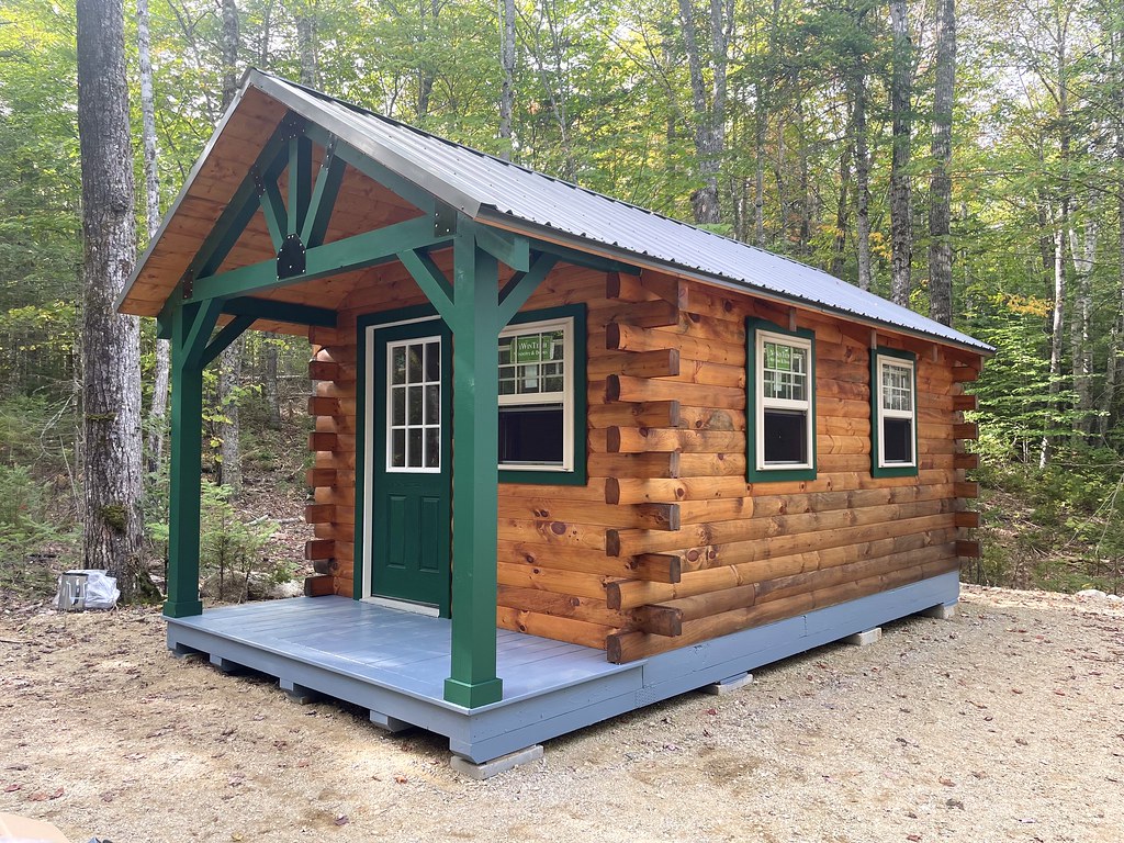
          We use something very similar in Downeast Maine. We have a little cabin on a lake in a pretty remote part of Maine - when the skeeters are bad - we need full body protection.

          Our cabin album:
          Maine - the way life should be...


          Regards,
          Scott
          <a href=https://www.trainsim.com/forums/filedata/fetch?filedataid=80663&type=full title=thumb_80663.png >thumb_80663.png</a>​ My Blender Models

          Comment

          • CSRX
            13500 Post Veteran


            • Oct 2005
            • 13646
            • Lincoln, ME
            • English
            • ORTS

            #35
            Scott, that cabin looks beautiful!
            Good choice on the company moving it too! They are great, and they do a lot of heavy lifting around here.
            -Shawn K-
            MEC Mountain Subdivision - Trackwork 70%, Scenery 35%
            ​

            Comment

            • scottb613
              2500 Post Veteran


              • Apr 2003
              • 2848
              • Downeast Maine (soon)
              • ORTS

              #36
              Originally posted by CSRX
              Scott, that cabin looks beautiful!
              Good choice on the company moving it too! They are great, and they do a lot of heavy lifting around here.
              Hi Shawn,

              Thanks - my wife and I have spent a week at a time in there - off the grid - even in bad weather - and we still get along.


              I have nothing but good things to say about the company - that magic trailer they used to place cabin (ours was the smallest the company sells) - is a technical marvel - it can maneuver into impossible spots. The crew doing the work were super.

              Regards,
              Scott
              <a href=https://www.trainsim.com/forums/filedata/fetch?filedataid=80663&type=full title=thumb_80663.png >thumb_80663.png</a>​ My Blender Models

              Comment

              • CSRX
                13500 Post Veteran


                • Oct 2005
                • 13646
                • Lincoln, ME
                • English
                • ORTS

                #37
                That reminds me that eventually I need to get a shed, maybe a bit smaller than that cabin, I believe they also do the same thing with sheds too in my area. So good to hear more good things about them.
                -Shawn K-
                MEC Mountain Subdivision - Trackwork 70%, Scenery 35%
                ​

                Comment

                • CSRX
                  13500 Post Veteran


                  • Oct 2005
                  • 13646
                  • Lincoln, ME
                  • English
                  • ORTS

                  #38
                  Scott,
                  Well, Finally got LIDEX to work properly with your efforts. Finally went into your TSRE V1.06 to polyveg. Trying to understand why this is happening...

                  Shows this in ORTS 1.6, but not in your TSRE.

                  At the moment I am using ENRDecid1, 2, 3, and 4 for the tree shapes.


                  In TSRE


                  I lay out the "New Ruler (PolyVeg)" with wrapping it along the border where all the trees are located, along the road, and get the overall section together.
                  I then "Plant Ruler (PolyVeg)", and once that process finished, I fine tune any trees that shouldn't be in spots that they are, I then click "Bake PolyVeg Tile". Once that is done, I save the route, and test, as as a result that is shown.

                  but when I do smaller sections, and not on a mountain or hill, this weird texture stretch doesn't seem to happen.. Hopefully this isn't another issue I have discovered, that is rendering me not being able to use this feature..
                  -Shawn K-
                  MEC Mountain Subdivision - Trackwork 70%, Scenery 35%
                  ​

                  Comment

                  • scottb613
                    2500 Post Veteran


                    • Apr 2003
                    • 2848
                    • Downeast Maine (soon)
                    • ORTS

                    #39
                    Hi Shawn,

                    For a shed - you may want to look at this place - my neighbor swears by them and mentions them almost every time I go up.
                    Storage Sheds, Storage barns, Camps, Garages, Horse Barns – Storage buildings, garages, camps, horse barns, homes, and gazebos to help you get organized

                    Thanks for the additional screens and explaining your process. Your settings all look good, and you’re following the planting and baking procedure correctly. I’ve planted and baked at 22K density without trouble, so your 15K setting doesn’t look unreasonable.

                    I’ve never seen this before, and honestly, I don’t know what’s causing it yet. Looking at that stretching, I suspect it could be a graphics card or driver issue, particularly since everything appears properly in TSRE. That’s only a suspicion—we haven’t established that it’s the trees, the hills, or Open Rails 1.6.

                    I'll do some testing on Open Rails 1.6 as well - as that is not a version I normally run.

                    Could you run Open Rails, visit the affected area, then close it and send me the OpenRailsLog.txt file normally created on your desktop? That should give me your OR build, graphics hardware, and any warnings recorded during that session.

                    Also, does it happen every time you run OR, and does the stretching change as you move the camera? Let’s get a little more information before having you change anything.

                    Regards,
                    Scott
                    <a href=https://www.trainsim.com/forums/filedata/fetch?filedataid=80663&type=full title=thumb_80663.png >thumb_80663.png</a>​ My Blender Models

                    Comment

                    • CSRX
                      13500 Post Veteran


                      • Oct 2005
                      • 13646
                      • Lincoln, ME
                      • English
                      • ORTS

                      #40
                      Hi Scott,
                      It is weird that if it was a graphics card issue, this would be showing in TSRE as well, but I have seen odder things. This happens each time I load ORTS V1.6 and even with the camera moving around, the stretched look still shows.


                      What is odd, is planted as individual shapes, and not as a group, this is the result. So I am completely lost, and confused on such a bizarre issue.

                      Attached Files
                      -Shawn K-
                      MEC Mountain Subdivision - Trackwork 70%, Scenery 35%
                      ​

                      Comment

                      • scottb613
                        2500 Post Veteran


                        • Apr 2003
                        • 2848
                        • Downeast Maine (soon)
                        • ORTS

                        #41
                        Originally posted by CSRX
                        Hi Scott,
                        It is weird that if it was a graphics card issue, this would be showing in TSRE as well, but I have seen odder things. This happens each time I load ORTS V1.6 and even with the camera moving around, the stretched look still shows.


                        What is odd, is planted as individual shapes, and not as a group, this is the result. So I am completely lost, and confused on such a bizarre issue.

                        Hi Shawn,

                        No worries - if this becomes too much of a PITA - I'll work on it.

                        I run at 3,500 meters in Open Rails on a more powerful video card, and your log shows 9,000 meters. I run TSRE at 4000 meters and if you are running my TSRE defaults your display less than that in TSRE. Try reducing your Open Rails setting to 3,500, restart the route, and check that same location. Leave everything else unchanged so we can see whether viewing distance affects the stretching. There were no memory errors in you log - but - it is something to try.

                        Thanks.

                        Regards,
                        Scott
                        <a href=https://www.trainsim.com/forums/filedata/fetch?filedataid=80663&type=full title=thumb_80663.png >thumb_80663.png</a>​ My Blender Models

                        Comment

                        • CSRX
                          13500 Post Veteran


                          • Oct 2005
                          • 13646
                          • Lincoln, ME
                          • English
                          • ORTS

                          #42
                          Holy crap how did I set that to 9k? Haha. Whoops. I'll try changing that.

                          I'm going to go through and test out each tree individually again as well, see if I can find the exact tree doing this. Maybe it's a corrupted shape file, but isn't showing that it is. Copy a similar shape and make a few edits, see if it goes from there.

                          Yeah, my card isn't the best, just a simple laptop gaming computer, but it handles this for the most part, as well as some other higher performing games, especially after upgrading my overall ram.
                          -Shawn K-
                          MEC Mountain Subdivision - Trackwork 70%, Scenery 35%
                          ​

                          Comment

                          • CSRX
                            13500 Post Veteran


                            • Oct 2005
                            • 13646
                            • Lincoln, ME
                            • English
                            • ORTS

                            #43
                            Scott,
                            It appears the shapes I was using, were corrupted somehow, did some tweaks, and managed to get the trees to behave properly. Sometimes they still show up wonky, but not nearly as bad as before, and seem to be more so off in the distance. I am thinking this is part of ORTS possibly taking forever to load up after going through the tree laying process.

                            I may end up going through anyways and redefining some stuff, I feel like some spots the trees are overlapping too much, and some areas they seem to be closer to the tracks than they should be. Either way, this is a game changer, and glad I got it working, for the most part.


                            -Shawn K-
                            MEC Mountain Subdivision - Trackwork 70%, Scenery 35%
                            ​

                            Comment

                            • Tonya37
                              Member

                              • Apr 2019
                              • 41
                              • Perth, Western Australia
                              • MSOR

                              #44
                              Hi Scott
                              I'm still feeling my way around GenX and Sco Lidex 1.5, so I have a couple of questions:

                              1. Is the GenX "Load Height" incompatible with Lidex? and related to that can Lidex be applied to a single tile? My question arises because if I mess up manual terrain editing often the easiest way to recover is by reloading the dem for the problem tile. I presume the "Load Height" still depends on local height files (50m resolution), which are not compatible with the 30m grid used by Lidex.

                              2. Am I correct in understanding that Lidex controls where vegetation is placed by using areas defined by land use maps? The reason I ask this is because I am working in the fiftes to sixties era, and some areas which are now built over were then woodland. If this is the case is it possible to override the land use definitions and place vegetation wherever desired? I thought that this would be possible by defining a polygon, but it seems that it is still limited to the vegetation areas within the polygon. Possibly it might be feasible to manually modify the exclusions?

                              3. For the areas that interest me, only the 30m dems are available. Just a suggestion for your consideration, it might be useful to be able to select only the dems applicable to the route - this would save having to wait while the program attempts to access the higher resolution dems. This of course would be a change of very minor importance, but would be convenient. Being able to have the 30 m dems available is a very significant feature, and is greatly appreciated.

                              In case anyone should encounter this, I got an error that the Geofabrik server could not be accessed because of a time-out error. My successful solution was to restart my computer.

                              I see that the Polyveg planter is quite happy to "plant" structures - perhaps it could be persuaded to build a few suburbs (or even cities!) by placing buildings in a grid? Just a thought.

                              Regards

                              Tony

                              Comment

                              • scottb613
                                2500 Post Veteran


                                • Apr 2003
                                • 2848
                                • Downeast Maine (soon)
                                • ORTS

                                #45
                                Originally posted by Tonya37
                                Hi Scott
                                I'm still feeling my way around GenX and Sco Lidex 1.5, so I have a couple of questions:

                                1. Is the GenX "Load Height" incompatible with Lidex? and related to that can Lidex be applied to a single tile? My question arises because if I mess up manual terrain editing often the easiest way to recover is by reloading the dem for the problem tile. I presume the "Load Height" still depends on local height files (50m resolution), which are not compatible with the 30m grid used by Lidex.

                                2. Am I correct in understanding that Lidex controls where vegetation is placed by using areas defined by land use maps? The reason I ask this is because I am working in the fiftes to sixties era, and some areas which are now built over were then woodland. If this is the case is it possible to override the land use definitions and place vegetation wherever desired? I thought that this would be possible by defining a polygon, but it seems that it is still limited to the vegetation areas within the polygon. Possibly it might be feasible to manually modify the exclusions?

                                3. For the areas that interest me, only the 30m dems are available. Just a suggestion for your consideration, it might be useful to be able to select only the dems applicable to the route - this would save having to wait while the program attempts to access the higher resolution dems. This of course would be a change of very minor importance, but would be convenient. Being able to have the 30 m dems available is a very significant feature, and is greatly appreciated.

                                In case anyone should encounter this, I got an error that the Geofabrik server could not be accessed because of a time-out error. My successful solution was to restart my computer.

                                I see that the Polyveg planter is quite happy to "plant" structures - perhaps it could be persuaded to build a few suburbs (or even cities!) by placing buildings in a grid? Just a thought.

                                Regards

                                Tony
                                Hi Tony,

                                Thanks for the detailed feedback — particularly your point about building routes set in an earlier era.

                                1. Reloading terrain

                                The source DEM resolution and the route’s terrain grid are separate things. LIDEX samples the elevation data onto the route’s terrain grid, so using a 30 m source doesn’t make the terrain incompatible with Load Height. However, reloading from a different elevation source can produce different heights and joins with neighboring tiles.

                                Yes, LIDEX can rebuild just the area you need. You can use a marker file or KML to control which tiles are processed, with Tile Radius set to 0 to avoid adding surrounding tiles. For an exact single-tile selection, you can also put its tile name in SCOLIDEXTiles.txt in your route folder and select Use Text File.

                                Select Overwrite to regenerate existing terrain, keep the same terrain resolution, and leave Clean Tile Wipe off. For terrain recovery alone, select Create Route Tiles and turn off DM and OSM/Map generation. Back up first, since rebuilding the selected tiles replaces their manual elevation changes.

                                2. Vegetation and historical land use

                                You’re correct — the automatic planting areas come from present-day OpenStreetMap data, so they won’t necessarily represent woodland from the fifties or sixties.

                                For my own 1940s route building, I still use today’s vegetation as a starting point. Where that leaves an open area occupied by a modern development today, I might put a farm instead. It’s a practical compromise: the current vegetation provides much of the landscape, and I fill in those openings with scenery appropriate to the period.

                                The Unrestricted ruler option allows planting outside the mapped vegetation areas, but it still respects exclusions for water, roads, railways, buildings, and developed land. That last part matters in your example: somewhere that is now developed can remain excluded even though it was woodland in your period.

                                Your example makes a good case for allowing historical-route builders to override those modern land-use restrictions. I’d want to check the best way to handle that before recommending manual edits to the generated exclusion files.

                                3. Selecting the elevation source

                                A Copernicus-only / 30 m option is a sensible suggestion for areas where the higher-resolution sources aren’t applicable. The current normal-terrain workflow checks the USGS sources before falling back to Copernicus, so being able to bypass those checks would be useful.

                                Regarding the Geofabrik timeout, all these online services can occasionally be unavailable or fail to respond. If that happens, I’d suggest waiting an hour or two and trying again. I suspect the successful attempt after your reboot was a coincidence — the service may simply have become available again in the meantime.

                                As for planting suburbs — an interesting thought! The planter can place building shapes, as you’ve discovered. Arranging them into convincing neighborhoods would need additional controls for spacing, orientation, and alignment with roads, but I can see the appeal.

                                Regards,
                                Scott

                                <a href=https://www.trainsim.com/forums/filedata/fetch?filedataid=80663&type=full title=thumb_80663.png >thumb_80663.png</a>​ My Blender Models

                                Comment

                                Working...