Distant Mountain Scenery And Such

Collapse
This topic is closed.
X
X
 
  • Time
  • Show
Clear All
new posts
  • tscraftsman
    Senior Member
    • Dec 2011
    • 117

    #1

    Distant Mountain Scenery And Such

    First of I just wanna say thanks to the Open Rails Team for all their hard work. I enjoy downloading the experimental versions that are released on Saturdays which is a highlight of my weekends lately this winter. Incredible improvements have been made in leaps and bounds with the signals, speed limits and track monitoring that i've noticed and im constantly noticing new improvements again keep up the great work!

    I was wondering if distant mountain rendering and new skies were on the foreseeable horizon? Pun intended lol

    Also AC traction modelling or DC traction improvements a possibility? My poor DC traction motors running in the red without penalty lol i could smell burning wires already lol. I find i'm getting constant wheelslips during dry conditions workin moderate power almost sporadically like there is a rail luber every couple of feet... I do like the bzzzt sound to alert me of the wheel slip. Just wish i could change that bzzzt to a rotory telephone bell sorta ring for an alarm like in some of the SD40s ive been on.
  • muskokaandtahoe
    3000 Post Veteran

    • Apr 2003
    • 3003
    • Silicon Valley, CA, USA.
    • ORTS

    #2
    DM's have been on the to-do list for long time. There are both technical and knowledge issues that have not been resolved.
    Dave Nelson
    sigpic
    Seldom visiting, posting less often that that.

    Comment

    • tscraftsman
      Senior Member
      • Dec 2011
      • 117

      #3
      Originally posted by muskokaandtahoe
      DM's have been on the to-do list for long time. There are both technical and knowledge issues that have not been resolved.
      What sort of specific issues might those be?

      Comment

      • eolesen
        9500 Post Veteran and Administrator


        • Dec 2002
        • 9583
        • NS MP245.4 CNO&TP South District
        • English, SQL
        • General

        #4
        Originally posted by tscraftsman
        Just wish i could change that bzzzt to a rotory telephone bell sorta ring for an alarm like in some of the SD40s ive been on.
        Try going to your [MSTS]\Sound\ directory and look for control_error_buzz.wav -- that's the global sound directory, and the file being triggered...

        Replace it with anything suitable that's in a wav format saved to "11.025kHz, 16bit, mono" -- mine is a copy of my iPhone's SMS alert...
        Last edited by eric; 03-12-2013, 07:48.
        If you like what you see here at Trainsim.com, be it the discussions and knowledge in the forums, or items available in our library, I hope you'll consider a paid membership to help support keeping the site operating.... Thanks!

        Comment

        • tscraftsman
          Senior Member
          • Dec 2011
          • 117

          #5
          Hey thanks for the tip! Doh why didn't I think of that! I'll see if i could extract some audio from a cabride video of a trip I took back in 03 with my old man as the hogger with a solid consist of CP SD40-2s when some sorta warning bells were goin off!

          Comment

          • ChrisD
            Member
            • Feb 2013
            • 48
            • Denmark

            #6
            tscrafsman

            When You get this authentic sound extracted, would You consider sharing this?
            ChrisD

            Comment

            • twpol
              Senior Member
              • Oct 2009
              • 434
              • United Kingdom

              #7
              We don't know the details of how MSTS implements DMs plus there are multiple competing ways we could implement them in OR. Ultimately it's just down to someone having the time and inclination to bash it out.
              James Ross
              Open Rails Management Team
              sigpic

              Comment

              • seagoon
                5000 Post Veteran

                • Jun 2001
                • 5161
                • Yamba, N.S.WALES, Australia

                #8
                Originally posted by twpol
                ....Ultimately it's just down to someone having the time and inclination to bash it out.
                Just so long as there is no head bashing involved, James.
                You guys are too important to be injured.

                Bruce
                IBM XT i386; 512Kb RAM; 5.25" FDD; 1.4Mb FDD; 5Mb HDD; VGA 256-colour graphics card; AdLib soundcard; DR DOS 6.0; Windows 3.0

                Comment

                • muskokaandtahoe
                  3000 Post Veteran

                  • Apr 2003
                  • 3003
                  • Silicon Valley, CA, USA.
                  • ORTS

                  #9
                  Originally posted by tscraftsman
                  What sort of specific issues might those be?
                  Expanding upon James' comments, not having the source code for MSTS does occasionally mean we've no idea how do some of the things they did. DM is one.

                  That said, there have to be better ways to do that sort of thing anyway... Kuju's solution appears to be to hang a vertical "curtain" around 2km away from the camera (easy enough) and to project upon it the net result of smashing all the 3d DM terrain data on to a 2d plane, culling away anything that isn't going to be seen. That works sortta ok when there are plenty of mountains between that curtain and the camera but it sux big time whenever there isn't; whenever there is a gap between the near terrain and the distant base the "curtain" trick is revealed for what it is -- a trick -- and you realize that whatever is on that curtain is supposed to be much, much farther away than it appears.

                  The obvious alternative is to render DM terrain pretty much like regular terrain. The downside of the simple solution is one gains a huge number of vertices to process when you extend the viewing distance and that results in a large percentage drop in fps. A more clever solution is to figure out how to apply the LOD concept so some of those vertices get culled by merging, as well as looking for any co-planar faces that could be merged, both before & after the application of the LOD and to do that well enough to not kill fps.

                  Which means there are actually two problems to solve: (1) how to reduce the data to manageable size and (2) to do that w/o much loss of performance.

                  And so James is spot on when he describes the need for someone to be inclined to take that on... and on doing that, to bash his way into a solution.


                  p.s. Open Rails has always been showing you more tiles than MSTS: OR displays 9, the one you are on and all 8 tiles around it -- a 36 square km area. MSTS does only 4 tiles, the one you are on and 3 other tiles closest to the camera -- a 16 square km area.
                  Last edited by muskokaandtahoe; 03-13-2013, 18:44. Reason: added postscript
                  Dave Nelson
                  sigpic
                  Seldom visiting, posting less often that that.

                  Comment

                  • jjtang
                    Senior Member
                    • Nov 1999
                    • 200
                    • .

                    #10
                    I think we may draw tiles far away using roughly sampling of 100m*100m (or something large). In the game, we just need the feeling that there are mountains far away, we do not care if it is 1000 meters high or 900 meters high.

                    Comment

                    • seagoon
                      5000 Post Veteran

                      • Jun 2001
                      • 5161
                      • Yamba, N.S.WALES, Australia

                      #11
                      Originally posted by jjtang
                      ...In the game, we just need the feeling that there are mountains far away, we do not care if it is 1000 meters high or 900 meters high.
                      I agree.
                      It's the impression that is needed to fill what otherwise appears as if the world ended just over........there!

                      Bruce
                      IBM XT i386; 512Kb RAM; 5.25" FDD; 1.4Mb FDD; 5Mb HDD; VGA 256-colour graphics card; AdLib soundcard; DR DOS 6.0; Windows 3.0

                      Comment

                      • markus1996
                        Senior Member
                        • Apr 2012
                        • 203
                        • Leoben, Styria, Austria, Europe

                        #12
                        yeah, DM´s would be a great introduction to OR, even if a mountain woul be "900 instead of 100" meters high or so - my system can´t process DM´s when running MSTS (too little memory), but in OR on best graphics settings, I get around 150 fps (vs about 30 in MSTS, DM turned off)

                        but, as OR introduced kind of a fade out of terrain visibility, the problem of the world just ending "over..... there" has actually become a great bit better, compared to MSTS. Nevertheless, DM´s would really make it even more realistic!
                        sigpic

                        Trains. Trains? Trains! =)
                        I usually hang out at www.elvastower.com (markus_GE).
                        Also take a look at my homepage: http://mgelbmann.jimdo.com/

                        Comment

                        • eolesen
                          9500 Post Veteran and Administrator


                          • Dec 2002
                          • 9583
                          • NS MP245.4 CNO&TP South District
                          • English, SQL
                          • General

                          #13
                          In addition to just rendering the terrain "normally" would it be practical to also render extremely tall objects like skyscrapers?... With the Chicago and New York routes in progress, when traveling on their real world counterparts, the skyline is usually visible from 10-20 miles out.

                          I agree that in general, a difference of being off by 100m in elevation might not be noticeable, but the width may be. I've seen some really distinctive mountain features obliterated by DM...
                          If you like what you see here at Trainsim.com, be it the discussions and knowledge in the forums, or items available in our library, I hope you'll consider a paid membership to help support keeping the site operating.... Thanks!

                          Comment

                          • csantucci
                            Senior Member
                            • Nov 1999
                            • 856
                            • Torino, Italy.

                            #14
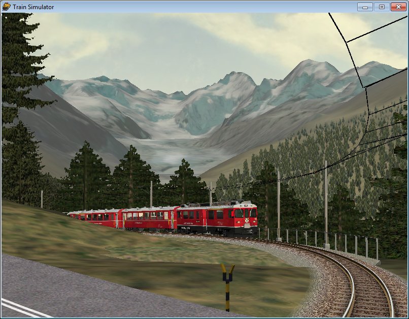
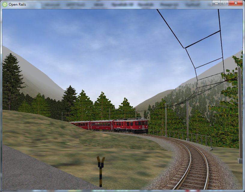
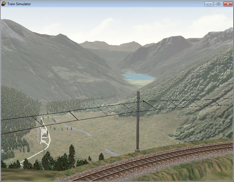
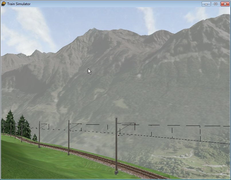
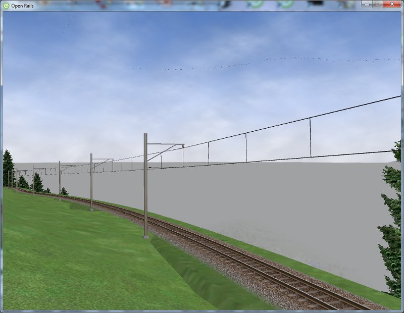
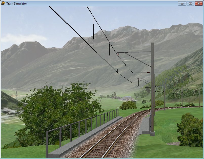
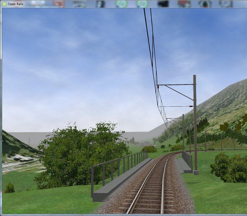
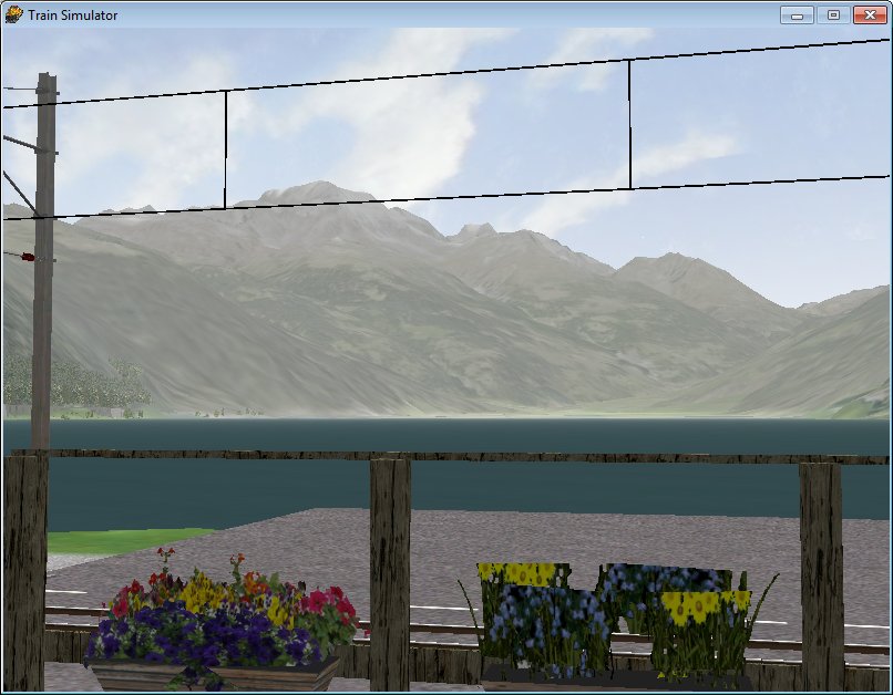
                            This post is dedicated to those, if any existing, that think that distant mountains aren't soo important.
                            You have comparisons of MSTS screenshots and ORTS screenshots taken from same locations in the Bernina freeware route.

                            Montebello under MSTS


                            Montebello under ORTS


                            Alp Grüm under MSTS


                            Alp Grüm under ORTS


                            Again Alp Grüm under MSTS


                            Again Alp Grüm under ORTS


                            Cadera under MSTS


                            Cadera under ORTS


                            Privilasco under MSTS


                            Privilasco under ORTS


                            Miralago under MSTS


                            Miralago under ORTS


                            I would also add some info about my experience:

                            1) MSTS does a quite good job with Distant Mountains: before running through new ways careful comparison is suggested
                            2) In no case elevation point density should be reduced with respect to MSTS: in locations with abrupt mountains like the Alps that would lead to a bad effect
                            3) MSTS is very flexible: while the route editor allows only for a maximum of 16 terrain patches per Distant Mountains tile, MSTS is able to manage for Distant Mountains also different configurations: the images above have been generated with a structure of 256 terrain patches per Distant Mountains tile, that is they have 16 times more elevation points than the standard DM structure; however they use the same .ace terrtex files as the standard DM structure, so I hadn't to reedit all such .ace files in this more dense configuration. MSTS manages this flawlessly (including offsets within .ace files) at runtime, and the result is evident. So I would hope that ORTS too is able to manage different elevation point density, so that every route creator can select the optimal density for his route.
                            Last edited by csantucci; 03-14-2013, 10:08.
                            sigpic

                            Comment

                            • mnjrr

                              #15
                              Hello,

                              If and when OR has Distant Mountains implemented, perhaps the developers could have a slider in the options menu to give users the ability to adjust how far out the mountains and other scenery elements (say skyscrapers) are visible. That way, OR users could take into consideration the processing demands of the topography and other criteria of the routes they run placed on their computer specs. I hope my description makes sense.

                              My friend and colleague Doug Relyea informed me that the Tristate route that we have been working on would need to have rendered an object (in this case a model of an obelisk that looks like the Washington Monument) at an estimated 8000 meters to have the object displayed in a sim as in real life and shown in the attached image.


                              The monument, known as High Point Monument, is on the ridge shown shown in the background of the image. The High Point Monument in real life is visible from the railroad yard at Port Jervis, NY. Doug pointed out to me that 2000 meters is the MSTS default. According to Doug, a sim "would have to load 49 tiles (Blue borders in RE or w files)" just to make the High Point Monument visible.
                              Last edited by Guest; 03-14-2013, 11:46.

                              Comment

                              Working...